On January 15, I ran the Daufuskie Island Marathon. Daufuskie Island is a coastal island in South Carolina. It’s just southwest of Hilton Head Island. There’s more lodging on Hilton Head Island, so that’s where I stayed.

I was originally scheduled
to run the Charleston Marathon this weekend.
Nine days before the race, I was notified that the race was
cancelled. Like many cities, Charleston
has been experiencing a surge of COVID-19 cases since the arrival of the
Omicron variant. The city felt their
resources were already stretched too thin to provide the necessary services to
support a large marathon in the city.
As I searched for other
marathons, I discovered the Daufuskie Island Marathon was the same day as the
Charleston Marathon. I had already
booked flights to Charleston, but the drive time from Charleston to Hilton Head
Island was only about two hours. The Savannah
airport would’ve been closer, but keeping my existing flights was less
expensive than rebooking to fly into Savannah.
Some people who were originally
signed up for the Charleston Marathon opted to do the Jekyll Island Marathon in
Georgia. On Wednesday, I learned that
the Jekyll Island Marathon was cancelled, because of severe weather that was
going to bring thunderstorms and strong winds.
My race was a day earlier, so it wasn’t going to be threatened by the storms.
I flew into Charleston on
Thursday and spent one night at a hotel in North Charleston. That evening, I got an email from Delta
advising me that my flights home might be affected by the storms. At this point, there wasn’t much I could do
about it. There weren’t any flights I
could catch on Saturday that would get me home the same day. I just had to wait and hope for the best.
I didn’t need to get to
Hilton Head Island until Friday afternoon, so I was able to spend Friday
morning doing some sightseeing in Charleston.
I started at Waterfront Park.
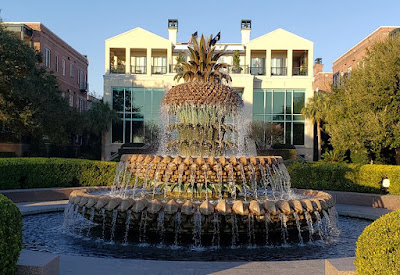
Next, I went to the Old
Exchange and Provost Dungeon. I walked
past Rainbow Row and followed the waterfront down to The Battery.


After that, I gradually
circled back. Along the way, I walked
past several historic houses, municipal buildings, and churches.

When I was done with my
self-guided walking tour of Charleston, I drove to Hilton Head Island. Along the way, I stopped for lunch.
After checking into my
hotel on Hilton Head Island, I drove to the Haig Point Embarkation Welcome
Center to pick up my race packet. My
route took me over the Coligny Beach Bridge.
This brought back memories of running across this bridge when I ran the
Hilton Head Island Marathon two years ago.
Thankfully, the race I was doing this year didn’t have any monster
climbs.
My race packet included
this warm jacket. The material was more
like a sweatshirt, but it has a zipper and pockets.

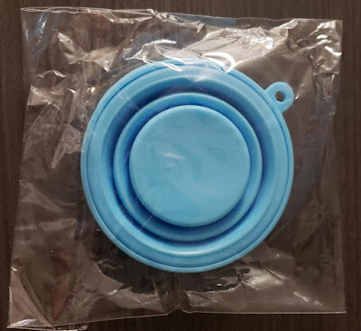
My race packet also included
this blue disk. I didn’t know what it
was at first. As it turns out, it’s a
collapsible drinking cup. More on that
later.
While I was at Haig Point
Embarkation, I also bought a round trip ticket for a ferry to Daufuskie Island
on race day.
I spent the rest of the
afternoon exploring Hilton Head Island and relaxing. I also organized my race gear and labeled my
drop bag. I wanted to have everything ready
before dinner, so I could get to bed early.
I set my alarm for 4:15 AM.
I had dinner at an
Italian restaurant that was about a mile from my hotel. After dinner, I had a beer tasting at Hilton
Head Brewery.
The marathon started at 8:30
AM, but I needed to be on a ferry that left at 6:30. Parking near the ferry terminal was limited,
so we were told to get there an hour early to look for parking. I was planning to get there by 5:30, but I
actually got there at 5:20. The closest
parking lots are reserved for members of the Haig Point Club. I was able find a parking spot in the closest
lot available to visitors.
I waited in the car for
about 10 minutes. Then I walked to the
Welcome Center, so I could use the bathroom.
People were beginning to board the 6:00 ferry. Since I was already there, I took that ferry
instead of waiting until 6:30.

The ferry ride took about
40 minutes. I was talking to another
runner who had his collapsible drinking cup with him. I learned from his that this was a cupless
race. We were all supposed to carry our
own cup, bottle, or hydration system. I
somehow missed that when I was reading the race information.
The ferry dropped us off
at Haig Point on Daufuskie Island. From
there, it was a short walk to the Runners’ Village, where we waited until the
race started. In the Runner’s Village,
there was a large canopy with tables, chairs, and several space heaters. The temperature was in the low 40s, so I was
expecting to be cold. Under the canopy,
I was fairly comfortable.

I asked the volunteers if
they had any spare drinking cups. They
didn’t. I was supposed to bring the one
in my race packet. That was back at the
hotel. Then they told me they would have
some paper cups at the aid stations.
They want people to bring their own cups, but they made provision for
people who didn’t.
Under the canopy, there
were tables with coffee, bananas, and cinnamon rolls. Nearby, they had port-o-potties and a place
to check gears bags. I brought a bag, so
I could check my warm-up clothes and have them to wear again after the race. I waited until about 30 minutes before the
race before taking off my warm-ups and checking them.
The course was a 13.1
mile loop. The half marathon was one
loop and the marathon was two loops.
They also had a 39.3 mile race called the triple half. That was three loops. If I was in better shape, I might have been
tempted to do that race, but I’m barely in marathon shape now. Ever since injuring my low back in late
November, I’ve cut way back on my training.
I ran a marathon four weeks ago, but since then my longest run was six
miles. I was confident I could finish a
marathon, but I expected to be slower than usual.
Most of the course was
paved. The start/finish area was paved
with brick, but as soon as we got going, we were on asphalt roads.
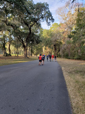
There aren’t many cars on
the island, but I saw several pick-up trucks.
Most people get around the island using golf carts.
I started at a pace that
felt easy. For the first few miles, I was
on pace for a four hour marathon. I didn’t
expect to continue at that pace. It felt
easy at first, but I knew it wouldn’t be sustainable for 26.2 miles.
In the third mile, we
reached an aid station. I saw small cups
of water and Gatorade on the table. I
drank a cup of Gatorade, but I didn’t discard the cup. I carried it with me for the rest of the
race. At the other aid stations, I
refilled it. That made me feel less guilty
about not bringing a reusable cup. I
wasted a paper cup, but only one.
About halfway through the
third mile, we turned onto a dirt road.
At first, the ground was damp enough for the surface to be firm. As I kept running, I noticed patches where the
ground was dry, and the footing wasn’t as firm.
I slowed down on this section. Earlier,
I was averaging about 9:05 per mile. On
this section, I averaged closer to 9:30.

As we approached five
miles, we turned onto another paved road.
Now that I had better traction, I picked up the pace a little, but I
didn’t get back to the pace I was running in the first few miles. As I passed the six mile mark, I realized
this was already as far as I’ve run in the last four weeks. I wasn’t inclined to push the pace too much.
Just past seven miles, we
turned onto another dirt road. This was
similar to the first dirt road. It was
firm in some places, but soft in others.
On this section, I slowed down even more. My pace here was about 9:45 per mile.
This section of dirt road
wasn’t as long. At most, it might have
been a mile and a half. When I got back
onto pavement, my pace didn’t improve much.
Later in the loop. We crossed bridges over a couple of streams. I had to stop to take pictures.
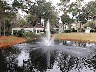
At the end of mile 11, I
was dismayed to see I had slowed down to 10:28.
Then I remembered I stopped several times to take pictures.
Next, we ran through a
neighborhood with some old homes. Some
of them probably date back to the 1800s.

With less than two miles
left in the first loop, we crossed a bridge that took us onto a golf cart path.
This was the only part of the course
that wasn’t wide enough for cars. For
more than a mile, we ran along the northern short of the island.

At first the path was
paved, but later the surface was crushed rock.
Unlike the dirt roads, this path had a nice firm surface with good
traction.

For most of the first
loop, I was following the runners ahead of me.
Now, for the first time, I had to pay attention to the course
markings. The course was marked with
small pink flags, similar to what you might see in a trail race. The flags were spaced close enough that you
could always see the next one in front of you.
The only way to miss a turn on this course is if you aren’t paying attention.
My 12th mile was also
slow, but I could once again attribute that to stopping to take pictures. In the last mile of the loop, we got back
onto paved streets. As I made the last
few turns, I could hear cheering and cowbells from the finish area.
I finished the first loop
in roughly 2:05. I was on pace to finish
in 4:10, but I had doubts about sustaining the same pace in the second
half.
As I began my second
loop, I knew what to expect. I couldn’t
remember every turn on the course, but I remembered the rough layout. There was a 2.5 mile section of paved
roads. Then there was a 2.5 mile section
of dirt road. Then there was another two
mile section of paved roads. Then a
shorter section of dirt road. Then a couple
more miles of paved road. Then the golf
cart path, leading into about half a mile of paved roads at the finish.
Segmenting the course like
this made it seem easier. I didn’t think
about running another 13.1 miles. Instead,
I broke it down into seven sections that each seemed manageable. I took them one at a time.
As I began the second
loop, I picked up my effort a little. I
didn’t know if it was wise, but I was willing to put some effort into picking
up my pace. I started to gain ground on
two runners who had passed me earlier, when I was stopping to take
pictures. I wanted to see if I could
reel them in.
On the first section of
paved roads, I ran a pace that was almost as fast as I ran it in the first
loop. I gained on the two runners ahead
of me, but I didn’t catch them yet.
Next, I reached the first
section of dirt road. Inevitably, I
slowed on this section, but I didn’t slow down as much as I did the first
time. By the time I finished this section,
I caught both of the runners I was chasing.
For the rest of the race, I continually caught and passed the runners
who were just ahead of me.
On the second section of
paved roads, I ran faster than I did on my first loop. My pace here was close to my pace in the
early miles. By the time I was halfway
through my second loop, I knew I was going at least as fast as I did on the first
loop. I felt, however, like I could hit
the wall at any time. I took it one mile
at a time.
I slowed down on the last
section of dirt road, but I didn’t slow down nearly as much as I did the first
time. This time, my pace was about 20
second faster than in the first loop. As
I got back onto paved roads, my next two miles were also a little faster than
they were o n the first loop.
I had just over three
miles to go. In my first loop, my 11th and
12th miles were my slowest. In both of
those miles, I made multiple stops to take pictures. This time, I wasn’t stopping. I wasn’t going to see anything new, so I just
focused on running.
I felt like I was fading,
but I kept up my effort. I knew my next
mile would be an easy comparison. The
first time I ran it in 10:28, but only because I stopped a few times. This time, I ran that mile in nine minutes
even. It was my second fastest mile of
the race.
I had just over two miles
to go. I was almost to the golf cart
path along the shore. I slowed a little
in that mile, but it was still more than 30 seconds faster than the corresponding
mile of my first loop.
Now I knew I would run
negative splits. As I reached the last
aid station, I refilled my cup for the last time, drank my Gatorade, and tossed
the cup into the trash. I had roughly
one mile to go. I was struggling, but I
did my best to limit the damage.
When I got back onto
pavement for the last time, I saw a runner who was beginning to pull away from
me. I tried to catch him, but I couldn’t. He was finishing strong, and I was just
hanging on. That mile wasn’t as fast in
this loop, but I was still going to run negative splits by a wide margin.
I finished in 4:06:57. I ran negative splits by roughly three
minutes. Most of that was attributable
to not taking pictures in the second loop, but I think I also ran a bit
faster.
There was a ferry leaving
for Hilton Head Island at 12:40. The
next one wouldn’t be until 1:40. I might
be able to catch the 12:40 ferry, but I only had a few minutes to get there.
I rushed through the
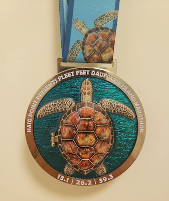
finish area so quickly, the volunteer with finisher medals had trouble catching
me. It’s a nice medal. It features a sea turtle. The shell opens to reveal an image of the
Haig Point Lighthouse.
After getting my medal, I
walked quickly to where the gear bags were.
The volunteers had arranged them on the ground, so I was able to find my
bag quickly. After picking up my bag, I
ran (as best I could) to the landing, and boarded the ferry just seconds before
it left.
I would’ve been nice to
have time to cool down and have a beer in the finish area, but I didn’t want to
wait an hour for the next ferry.
Catching this one was my reward for running hard in the second half of
the race.
Had the Charleston Marathon
not been cancelled, I probably would never have done this race. I’m glad I did. Getting to and from this race takes extra
time, but I think the experience was worth it.
After driving back to the
hotel and getting cleaned up, I took the time to jot down my recollections of
the race, so I wouldn’t forget. Then I
went out for an early dinner. The
restaurant had steps. Going up the steps,
I noticed some discomfort in my right knee.
I also noticed my knee when I walked down the steps as I left. Most days, I don’t notice my knee, but
clearly it’s not fully healed yet.
A storm system moved
through during the night. This is the
same storm that caused the cancellation of the Jekyll Island Marathon, which
was scheduled to take place on Sunday.
My flight out of Charleston wasn’t until 12:22 PM, but I got up early
and started driving right after breakfast.
It’s normally a two hour drive, but I wanted to allow extra time in case
the rain caused delays.
The shortest route to
Charleston includes roads through low-lying area that are prone to flooding
during periods of heavy rain. I took a
longer route that’s farther inland.
As I left Hilton Head
Island, I encountered sections of road with standing water. It was still dark, so I couldn’t see the water
until I drove over it. Each time, it was
a bit jarring as the car suddenly slowed down, and I felt the ABS engage for a
second or two.
Once I got to I-95, I
didn’t have to worry about water on the road.
Freeways are generally designed to have good drainage. Instead, I had a new concern. Shortly after I got onto the freeway, I saw one
of the dashboard indicator lights come on.
It was a symbol I had never seen before, and I didn’t know what it
meant.
Ideally, I would’ve
pulled over to get out the owner’s manual and see what that indicator
meant. The road was slick, and visibility
was poor, so I didn’t feel like it was safe to pull over.
The indicator turned off
after about a minute, but a few minutes later if came on again. I was two miles from a parking area, but it
was for trucks only. When I got to the
exit, it said no cars allowed. I had to
press on until I reached a town.
Over the next 15 minutes,
the mysterious dashboard indicator turned on about four more times. Each time, it turned off again. By the time I left the freeway, it was no
longer coming on again.
The second half of my drive
was along local roads. As soon as I got
off the freeway, I started encountering puddles. By now, there was enough light that I could
see them coming. Where there were two
lanes, I drove in the left land, to avoid puddles on the side of the road.
The mysterious dashboard
indicator came on one more time. By
then, I was less than 30 miles from the Charleston Airport, so I pressed on.
Before returning my rental
car, I needed to fill my tank. While I
was at the gas station, I took a few minutes to get the owner’s manual out of
the glove compartment. The indicator
light was a pedestrian warning.
Presumable, there’s a camera on the front of the car, and it’s supposed
to warn you if you’re in danger of hitting a pedestrian in the roadway. I can only assume that the rain was
obstructing the camera, so it was giving me false alarms.
I got to the airport
three hours before my scheduled flight.
The guy at rental car return was a runner. He saw my Boston Marathon jacket, and we talked
about races for several minutes. During
our conversation, I learned that the 7:30 flight to Atlanta was cancelled. When I got into the airport, I saw on the
departure board that several flights were cancelled. Mine was still listed as “on time,” but I was
making connections in Atlanta, so I had to worry about the weather in both
cities.

After sitting in a car
for two hours, my lower back was bothering me.
I wanted to check my bag, so I wouldn’t have to hoist it into the
overhead bin on my flights. I chose to
carry it onto the plane instead, so I wouldn’t be stuck without my luggage if I
had to spend the night in either Charleston or Atlanta.
While I was waiting in
the Charleston airport, I saw that my flight was still scheduled to depart, but
all the later flights into Atlanta were cancelled. The problem wasn’t the weather in Charleston. It was freezing conditions in Atlanta, where
it was snowing. Early and late arrivals
into Atlanta were cancelled, but my flight was arriving at the warmest time of
the day. Of course, getting to Atlanta
was only half the problem. I still had
to worry about my flight from there to Minneapolis.
When I arrived in Atlanta, I made the mistake of carrying my bag off the plane. I should've rolled it. Walking off the plane while carrying that bag seriously aggravated my lower back. It bothered me for the rest of the day.
I had a two hour layover in Atlanta. For most of that time it was snowing, but it was warm enough that the snow wasn't accumulating on the runways. I got in and out of Atlanta during the afternoon, when it was warmest. Had it been just a few degrees colder, I might have been stuck there overnight.

No comments:
Post a Comment